
Proposed development at former St Mary's Independent School, Bitterne Park
Sovereign Housing Association has submitted a detailed planning application to Southampton City Council (application reference: 22/01341/FUL) in relation to land at the former St Mary’s Independent School, Bitterne Park for:
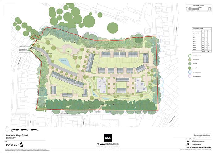
“Re-development of the site to create 84 dwellings (8 x one bed apartments, 24 x 2 two bed apartments, 27 x two bed houses, 22 x three bed houses, 3 x four bed houses) with associated car and cycle parking, landscaped areas, play space and associated works.”
The demand for homes, and in particular affordable housing in this area has changed. There is a real need to provide new affordable homes of different types to meet the local housing need. Our proposal will help deliver 84 high quality and extremely sustainable homes for affordable rent and shared ownership, assisting the city in reducing its current deficit of 7,500 affordable homes.
In addition to the following information, please do read our FAQs towards the bottom of the page to find out more.
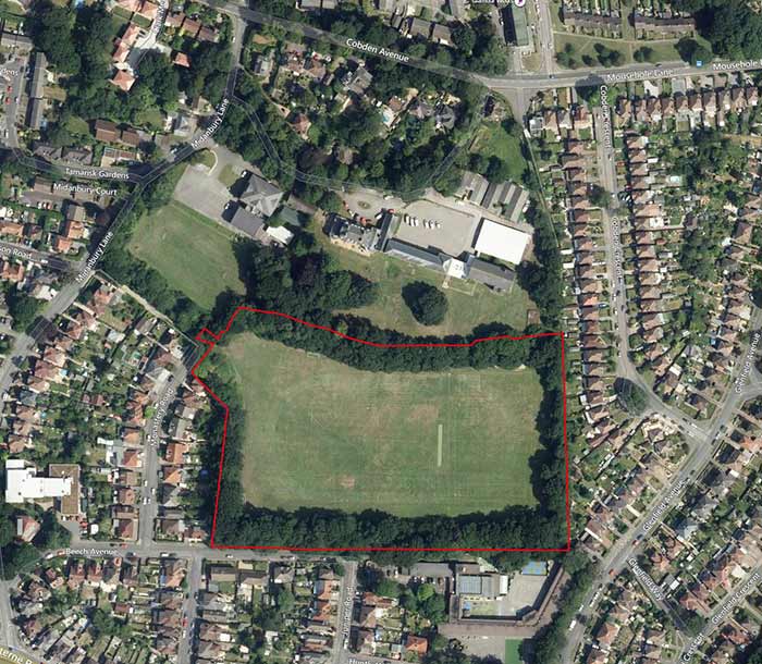
Site location
The site is located within the grounds of the former St Mary’s Independent School located in the Bitterne Park area of Southampton. The area proposed for residential development currently comprises the former playing field to the south of the school accessed from Monastery Road. Following the closure of St Mary’s Independent School in 2020, the playing pitches have become surplus to requirement.
Public consultation
Draft proposals were presented at our consultation event on Monday 18 July 2022. The full set of exhibition boards and feedback form can be downloaded via the links below:
We would like to thank everyone who has provided feedback.
Following pre-application engagement with the Council and extensive consultation with the community our initial proposals and supporting material have been updated to reflect feedback received, including:
- Open space increased and located to be more legible and central to development, providing a parkland setting to the heritage asset.
- Shared surface pedestrian priority street incorporated along north side of site.
- Improvements to pedestrian access and permeability connecting the site to existing footpaths to the east, west and south of the site.
- Attenuation pond relocated to work with a more coherent public open space and designed reviewed to ensuring betterment over the current greenfield drainage rates by discharging less surface water into the existing sewerage network than at present.
- Access road alignment altered so not to dissect public open space.
- Additional traffic and parking surveys have been commissioned to verify and support existing surveys.
- Stronger, more formal definition to edge of public open space provided following identified extent of setting of listed building on adjoining land.
- Road along south of site omitted, freeing up space for greenway providing ecological, play and open space amenity and offering a car free route through the site.
- Flats relocated to the south east corner allowing a better setting to the open space.
- Clustered parking provides greater flexibility for future re-use if demand allows.
Masterplan
All our submitted plans and documents can be viewed on Southampton City Councils website www.southampton.gov.uk/planning/planning-applications/ and searching the application reference: 22/01341/FUL
All plans will remain subject to change through the planning determination and will be updated regularly on this webpage.